2D and 3D Geophysical and Geological Modelling
Gondwana Geoscience offers services in 2D and 3D geophysical modelling for gravity, magnetics and EM data, as well as 3D Geological Modelling for geological and well log data. Gondwana Geoscience specialises in multi-data integration through 3D geological earth modelling.
Geological and geophysical modelling are essential modern tools to help explorationists understand the nature of the geology in the area they are exploring. Often geological models are difficult tasks to undertake and require detailed, specific knowledge from drill core measurements, cross sections and structural mapping. Geophysics enhances 3D geological modelling, by allowing inferences about depth, shape, size and orientation as well as structure to be inferred in 3D earth modelling space. Whilst 2D geophysical modelling is often used and is often very useful when information data sets are small and restricted to 2D (i.e. 2D seismic profiling or 1D/2D electromagnetic profiling), the capacity to build models rapidly in 3D with relatively sparse geological information, supplemented by geophysics, cannot be underestimated in terms of its value to the explorer.
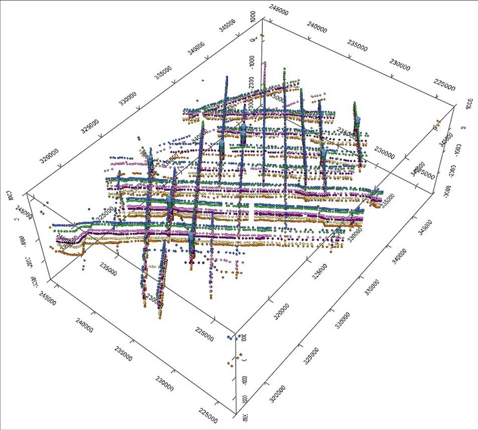
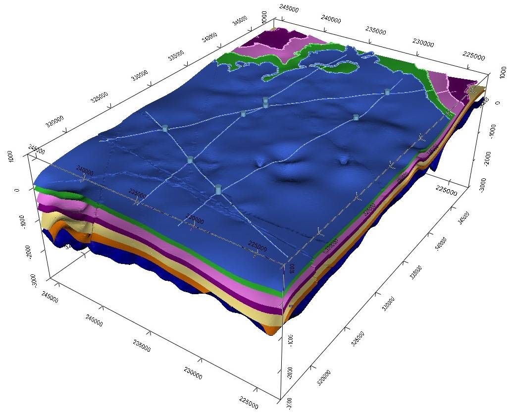
GeoModeller is a tool developed by Intrepid Geophysics. This product grew out of a research collaboration between Intrepid, BRGM France, Geoscience Australia and a number of the state geological surveys. GeoModeller is an implicit geological modelling tool, which computes 3D geological models based on geological contacts, orientations, geophysical information and structural inferences. In a similar fashion to other implicit 3D geological modelling software, geological models are computed based on these sets of information, then rendered in 3D geological space using polyhedral meshing. Models can be built rapidly using relatively sparse geological constraints or highly detailed geological information, then computed at scale to render the appropriate level of detail. The models can then be populated by borehole log data with geochemical and petrophysical attribute information, which can be used for 2D or 3D geostatistical modelling. Geochemical and petrophysical 3D models can be used to validate and iteratively drive changes to 3D geological model outcomes. Furthermore, potential field geophysics can also be used within the suite to forward model the gravity or magnetic responses of the model, based on the inferred or measured petrophysical information. 3D stochastic Monte Carlo inversion is also available and can also be used to defined litho-property models. This makes the tool an extremely powerful method of building models of the earth, containing data from across the different spectrum of methods of exploration and is applicable in all types of exploration industries, including groundwater, basin modelling, geothermal modelling and mineral deposit modelling.
Additional geophysical tools available within the software include, temperature and temperature gradient modelling and 1D/2D airborne EM modelling.
Mineral deposit modelling projects have included Pilbara and Gawler Craton Iron Ore, Northern Territory Copper, South Australian Uranium and Albany Fraser Province Nickel. Geothermal modelling projects have been undertaken in both Columbia and South Australia. Basin modelling projects have been performed with the Cooper-Eromanga Basin, East African Rift Valley, Gulf of Mexico, Canarvon Basin, Browse Basin and Cauvery Basin.
Data Processing
Gondwana Geoscience has vast collective knowledge in the areas of Geophysical Data Processing. Whilst the principal areas of knowledge cover reduction, levelling, editing and gridding of potential field and radiometrics data, we also have experience in marine seismic data processing, IP and airborne EM processing. Data processing knowledge also covers QC and Quantitative Methods for these types of datasets. Intrepid software is the primary tool used for potential fields and radiometrics, and a variety of other software for related and alternative processing.
Data Interpretation
Geophysical data interpretation and integration with other geoscientific datasets are a core service capability of Gondwana Geoscience.
The ultimate aim of good geoscientific data interpretation is to endow both the interpreter and the recipients of the interpretation with previously unheld knowledge of the area of study on the Earth, in a manner both informative and scientific.
Interpretation of geophysical data may occur on both a qualitative or quantitative basis.
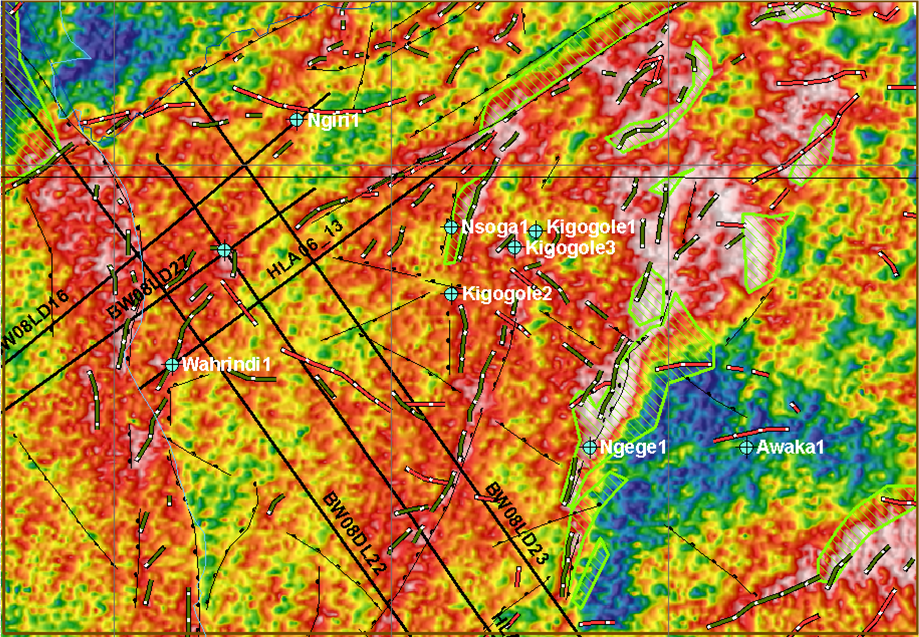
Qualitative interpretation creates maps in GIS applications (eg ArcGIS, ER Mapper) through automated or manual analysis of 2D geophysical grids, for example Gravity, Magnetic, Electrical, Radiometric or Seismic, often through the application of various filters which are used to enhance the grids. Inferences can be made from the anomalies delineated in the maps, which can then be classified into domains separated by interpreted geological or structural boundaries, and ranked for exploration targeting. Gondwana Geoscience also has experience in interpretation and processing of LANDSAT and Aster/Raster datasets.
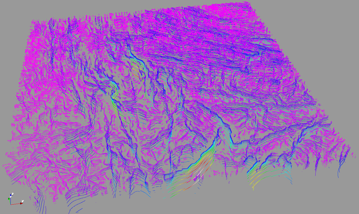
Quantitative interpretation is a subset of Data Processing. Grids or datasets my be put through transformative processes such as Multi-Scale Edge Detection or Worming for lineament detection, Euler Deconvolution, Tilt-Depth or Spectral-depth, Murthy&Rao and many other methods for depth estimations. These estimations can be used as a first estimate of depths for later processes such as 2D or 3D Modelling, whilst the auto-lineament interpretation can be used to supplement manual GIS interpretations.
Gondwana Geoscience's particular expertise in Tensor Analysis of Airborne Gravity Gradiometry (AGG/FTG) data allows access to tools which work directly on measured gradient datasets which have much higher spatial resolving power than conventional methods at shallower depths for regional exploration in basin or mineral settings.
Quality Control
Gondwana Geoscience has collective experience of hundreds of thousands of line kilometres of airborne and marine geophysical data QC, with particular recent emphasis on AGG/FTG surveys. In 2016 since the establishment of Gondwana Geoscience, approximately 40000 line km of Falcon AGG and FTG data in Indonesia were QC-ed by Gondwana. The ability to perform Quality Control services is dependent on years of experience of working with the data in both processing and interpretation.
Quality Control services tie in with both Project Management and Data Processing. QC also (in principle) should mean assistance in Survey Design and selection of suitable geophysical contractor for clients, as well as acting at times as liason between contractor and client for management of processes during survey. It also involves inspection of Delivered Products and occasionally even QC of Interpretation.
Gondwana Geoscience is one of only a very small number of organisations worldwide with the capability to perform QC of Tensor AGG and FTG Gradiometry data. We envision further the ability to QC FTMG magnetic tensor data as this data type comes more into general use.
Project Management
Gondwana Geoscience offers project management services, which include;
– Geophysical survey design
– Geophysical field contractor tendering
– Logistics and stakeholder liaison
– Geophysical contractor management
– Geological data and logging management
– On-call data management and validation
– Data processing and interpretation
– Geophysical survey report with recommendations
– Geological exploration and reporting services
Geoscientific Advice and Training
Gondwana Geoscience has performed software training in potential fields and radiometrics methods on behalf of Intrepid Geophysics both as employees and contractors. The methods cover all facets of geophysics from processing, interpretation and modelling. Training and Advisory services have also been given independently at short courses and workshops. Areas where training has been performed include Australia, Ireland, Germany, Spain, India, Colombia, New Zealand and the USA.
Future ambitions for Gondwana Geoscience will include design of its own interpretation and modelling short courses, and expanding its capability to perform as a Geoscientific Advisory Service and Advocate for better exploration and teaching methodologies through academic or public institutions.
Geoscientific Advocacy info here